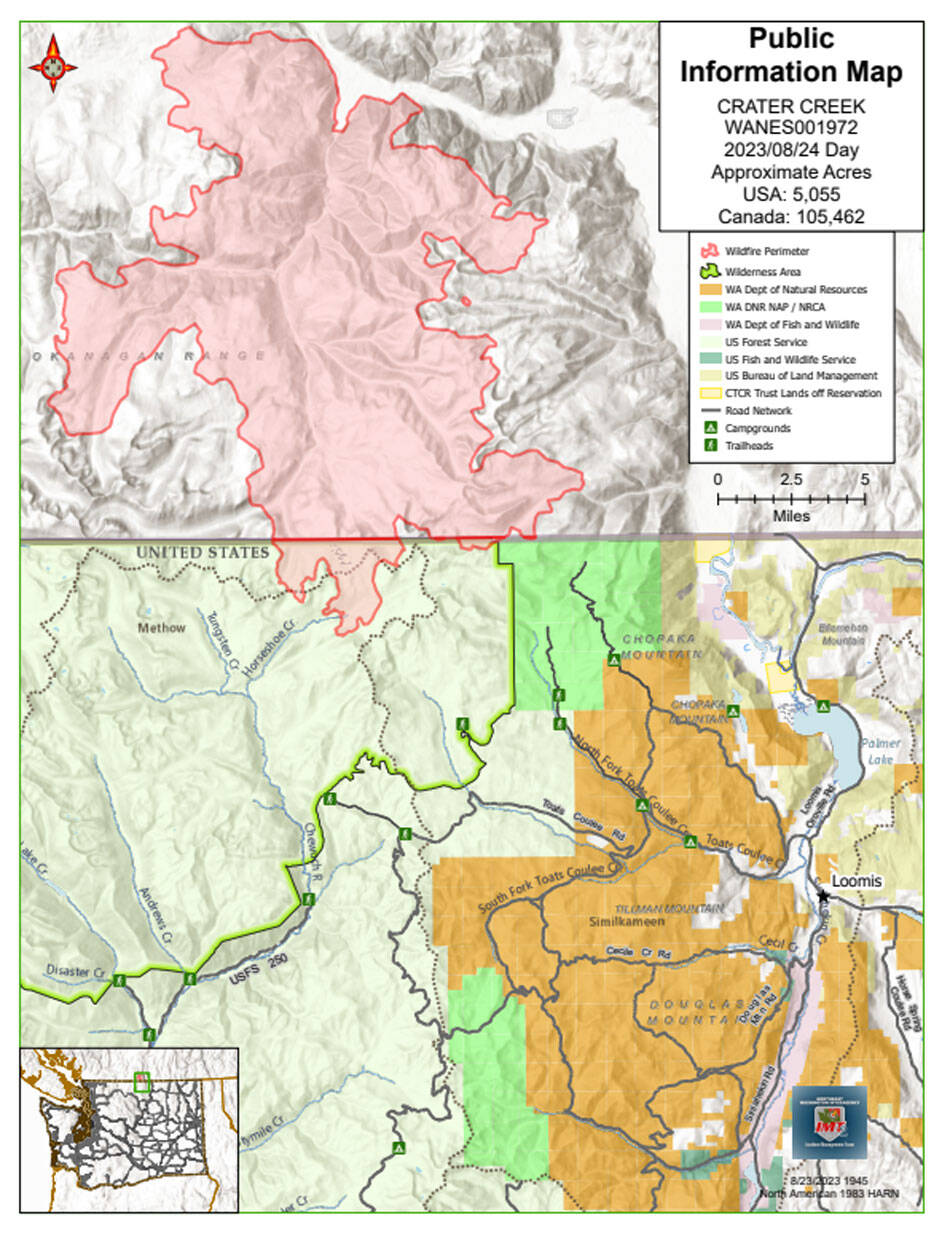
The Crater Complex includes the Crater Mountain Fire and the Upper Park Rill Fire in Canada. The fire, which is also burning on the U.S. side of the border is called the Crater Creek Fire.
TONASKET – The Thursday. Aug. 24 update on the Crater Creek Fire, which is a lightning-caused fire that started on Aug. 18 and jumped the border into the U.S., is an estimated 5,055 acres and remains zero percent contained on the U.S. side, according to Incident Commander Shane Robson.
The fire is burning in remote and rugged terrain with poor access, it is not currently threatening critical infrastructure or municipal watershed integrity. No structures have been lost in the fire.
“Fire supervisors have been scouting opportunities to dig a direct line near the border that would be anchored between the Snowy Mountain Fire and Newby Lake Fire scars. Due to favorable weather conditions over the past few days, fire behavior has greatly diminished,” said Robson. “Recreation values continue to be assessed and protected.”
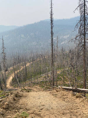
Burn scar with mechanically cut fireline, 2023. USDA Forest Service photo.
People are asked to check up-to-date road closure information on the websites below, be considerate of these areas for not only public safety but also the safety of the firefighters and machinery. Daily communication with British Columbia fire officials is ongoing, a BC Wildfire Service Team from Australia arrived yesterday to manage the Crater Complex of fires north of the U.S. border.
Closures: Closure Orders have been issued by the US Forest Service, BLM, and DNR.
USFS: Okanogan-Wenatchee National Forest and the Colville National Forest for the following campgrounds, roads, and trails:
Developed Campgrounds Closed
Long Swamp Campground, 14 Mile Campground
Roads Closed
FSR 3900100, 110, 105, FSR 3900395, FSR 3900415, FSR 3900500 (Iron Gate), 502, 505, 510, 515
Trails Closed
Trail No. 340 Long Draw, Trail No. 341 Deer Park, Trail No. 342 Windy Peak, Trail No. 343 Clutch Peak, Trail No. 360 Basin Creek, Trail No. 362 Windy Peak, Trail No. 375 Albert Camp, Trail No. 387 Middle Fork, Trail No. 505 Coleman Ridge from junction with Trail No. 561 north to junction with Trail No. 510, Trail No. 510 Chewuch from junction with 510A Cathedral Driveway north to junction with Trail No. 565 Lesamiz, Trail No. 533 Boundary Trail (Pacific Northwest National Scenic Trail) from the junction of the lower Cathedral Lake Trail No. 545 junction east to the Forest Service boundary with the Loomis State Forest, Trail No. 533.2 Smith Lake, Trail No. 534 Tungsten Creek, Trail No. 561 Fire Creek.
https://www.fs.usda.gov/alerts/colville/alerts-notices or https://www.fs.usda.gov/alerts/okawen/alerts-notices
WA DNR: The Washington State Department of Natural Resources has closed the northern block of the Loomis NRCA. This closure includes the Disappointment Trailhead, as well as Cold Springs Campground, Cold Springs Overlook, and Chopaka Lake Campground. The Cold Springs Road is closed six miles past the intersection with Toats Coulee Road, and the Fourteen Mile Road is closed 1 mile past the intersection with Toats Coulee Road. https://www.dnr.wa.gov/LoomisLoupLoup.
BLM: The Chopaka Lake Campground is closed until further notice.
Update from the BC Wildfire Service on the Crater Complex
The Crater Complex of fires, which includes the Crater Mountain fire and Upper Park Rill fire, both burning near Keremeos, are listed as “out of control.”
The Crater Mountain Fire, 19 kilometers southwest of Keremeos, was discovered July 22 and is an estimated 44,000 hectares (10,8726.37 acres).
“We are working with our U.S. partners in the response to this wildfire. Cathedral Lake Lodge appears to be unaffected by fire (however ground truthing is still to occur), following RDA visual via helicopter this morning,” said the BC Wildfire Service. “Heavy equipment is continuing to establish some containment lines to the north and northwest of the fire, using existing roads and cut blocks. Heavy equipment is being supported by BC Wildfire Service firefighters, contract crews and Weyerhaeuser resources.”
Crews are ensuring all fuels between fire edge and guards around homes are fully extinguished or blacklined. Structure protection crews are still active on the northeast portion, no significant change has been observed in that area.
There are Evacuation Alerts and Orders associated with the Crater Creek wildfire issued by the Upper Similkameen Indian Band, the Lower Similkameen Indian Band and the Regional District of Okanagan-Similkameen.
The Upper Park Rill Fire, 13 kilometers northeast of Keremeos, was discovered Aug. 19 and is 1,830 hectares (4,522 acres).
“Crews and heavy equipment continue to make good progress on containment objectives. Heavy equipment has completed guard on the top of the fire and has made good progress on line construction moving south down both the east and west flanks tying into handline guards. Heavy equipment is looking to establish machine guards along the southern flank and tie into handline guards.
“Crews are continuing mop-up of successfully conducted small-scale hand ignitions along the machine guard to reinforce the guards and bring the fire down to workable terrain. Bucketing with medium helicopters in the northeast southeast of the fire ground to ensure fire walks safely to guards,” said BC Wildfire Service.
Structure protection crews are assessing and patrolling structure protection equipment.
Contact the Regional District of Okanagan-Similkameen for the most up-to-date information on Evacuation Alerts and Orders associated with this wildfire: https://emergency.rdos.bc.ca/latest-updates/.