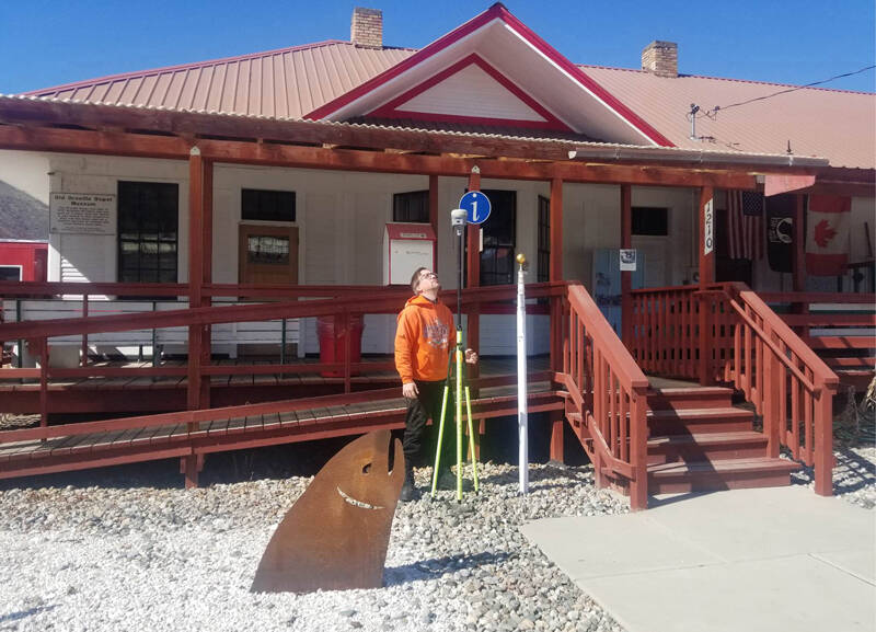
OROVILLE – Patrick Miller from the U.S. Geological Surgery (USGS) came to the Oroville Depot Museum to make a water level mark to show where the town was during the 1894 flood.
That flood was considered the area’s highest in recorded history and the most devastating, according to Miller. The 1894 flood reached a level of 927 feet of elevation or 18 feet above the regular water level of 909 feet today.
There are signs and displays at Oroville’s Osoyoos Lake Veterans Memorial Park that talk about the high water mark, according to Miller.
“These give a very good explanation of the flow and history of three levels of some of the worst flood in our short history,” he said.
Osoyoos Lake is typically held at between 909 and 913 feet by Zosel Dam. The water level is set by the International Joint Commission (IJC), because it is shared between the U.S. and Canada.
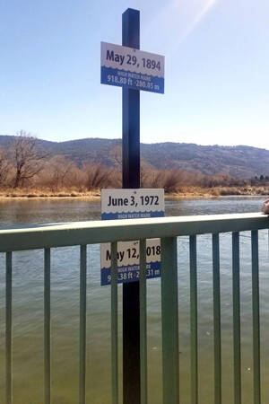
“The flag pole at the Depot Museum on Ironwood Street shows us that the base of the flag pole is nine feet above the high water mark of 1894,” said Arnie Marchand with the Borderlands Historical Society, adding this was because there was no flood levy built at that time, or for the next 60 years.”
The floods in 1894, 1948 and 1972 were pretty devastating. The nearest dry land during some of these floods was at the Berg Funeral Home on Main Street, several blocks from the Similkameen River.
“It seemed it was the only place to get on dry land at those flood events in Oroville,” said Marchand.
Oroville lies between two rivers, the Okanogan on the east and the Similkameen on the west. Miller reminded people that seepage from flood events, water from underground that rises to the surface, causes as much damage as the rivers overflowing their banks. During the last century, the floods of 1948 and 1972 caused the basements of some of the stores on Main Street and items stored there were lost. Many homes also suffered water damage to their basements.
There are 100-year flooding events and then there are unexpected events like November’s high water in the North County which was caused by sudden run off from torrential rain in the mountains north of Oroville leading to flooding.
“Those have not caused devastation to a high degree, but they do cause damage,” said Miller.
According to their website, “The USGS collects flood data and conducts targeted flood science to help federal, state and local agencies, decision makers and the public before, during, and after a flood. Our efforts provide situational awareness, drive predictive models, inform infrastructure design and operation, undergird floodplain mapping, assist flood constituent/load quantification and facilitate flood impact assessments.”
The Borderlands Historical Society invites people to “come to the Depot Museum and see more history shown to you for your enjoyment. We are here to make you glad you came.”