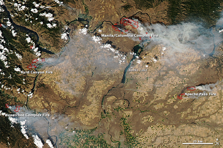

Department of Ecology news release
YAKIMA – Smoky skies continue to blanket much of Central and Eastern Washington as a number of fires burn from the Canadian border to the Columbia River border with Oregon.
Smoke from the lightning-sparked wildfires is gathering in the foothills and valleys of the Cascade Range around Wenatchee, Ellensburg and Yakima and the ranges around Spokane, Clarkston and elsewhere in the Columbia Basin.
Over the next few days, air quality in some areas will improve during the day and degrade at night, while the reverse could be true for other areas. Smoke from wildfires in Idaho is likely to impact the far eastern part of the state as well. Though some relief is expected by late Friday, conditions conducive to further wildfire growth are possible on Saturday.
Crews from the U.S. Forest Service and the Washington Department of Natural Resources (DNR) are battling the blazes, with reinforcements brought in from across the nation.
Wildfires produce plenty of harmful smoke. The biggest threat to people’s health comes from the fine particles in smoke. These tiny particles can get into your eyes and lungs, where they can cause health problems such as burning eyes, runny nose and illness such as bronchitis. Fine particles also can aggravate heart and lung diseases, and even lead to death.
Weather influences how severe smoke impacts may be. If the air is stagnant, the concentration of fine particles increases in the air locally. If winds are blowing, they can move smoke rapidly to areas hundreds of miles downwind from a fire.
When smoke and fine particle levels are high enough, even healthy people may be affected. To protect yourself, it’s important to limit your exposure to smoke – especially if you are susceptible. Here are some steps you can take:
The Washington State Department of Health recommends that people who are sensitive to air pollution limit the time that they spend outdoors when smoke is in the air.
Children also are more susceptible to smoke because:
Their respiratory systems are still developing.
They breathe more air (and air pollution) per pound of body weight than adults.
They’re more likely to be active outdoors.
Pay attention to air quality reports. The Washington Air Quality Advisory (WAQA) is the tool that that the Washington Department of Ecology (Ecology) uses to inform people about the health effects of air pollution. WAQA includes information about ground-level ozone, fine particles and carbon monoxide. WAQA is very similar to the EPA’s Air Quality Index (AQI). Both use color-coded categories to show when air quality is good, moderate or unhealthy. The difference is that WAQA shows that air quality is unhealthy when there are fewer particles in the air.
Use common sense. WAQA and AQI may not have immediate information on conditions in your specific area. If it looks and smells smoky outside, it’s probably not a good time to go for a jog, mow the lawn or allow children to play outdoors.
If you have asthma or other lung disease, follow your doctor’s directions on taking medicines and following your asthma management plan. Call your doctor if your symptoms worsen.
If you have heart or lung disease, if you are an older adult, or if you have children, talk with your doctor about whether and when you should leave the area. When smoke is heavy for a prolonged period of time, fine particles can build up indoors even though you may not see them.
Turn air-conditioning units to “recycle” mode so they don’t draw in outside air.
Don’t think that paper “comfort” or “dust masks” are the answer. The kinds of masks that you commonly can buy at the hardware store are designed to trap large particles, such as sawdust. But they generally will not protect your lungs from the fine particles in smoke.
Read more at the Dept. of Ecology website. Updates on the various Eastern Washington fires can be found at InciWeb. And if you have a high-speed connection, ArcGIS has an interactive map of fire locations.