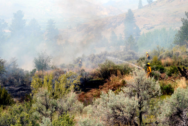
Fire crews from the DNR and the Mt. Hull, Oroville and Tonasket fire departments put out flare ups while a dozer was called in to carve out a dozer line last Sunday.
Richter Fire burning in BC near U.S. Border
OROVILLE – The Abie Lane Fire, which started Mother’s Day afternoon, was listed as 80 percent contained as of Sunday evening, according to Okanogan County Emergency Management.
The fire, which burned approximately 50 acres, started near 91 Abie Lane south of Oroville and continued up the hillside toward Swanson Mill Road on Sunday, May 12. Emergency Management sending out a Level 1 Advisory to be cautious of emergency vehicles just after 2 p.m. The advisory said, “Persons should be aware of their surroundings and take action if needed.”

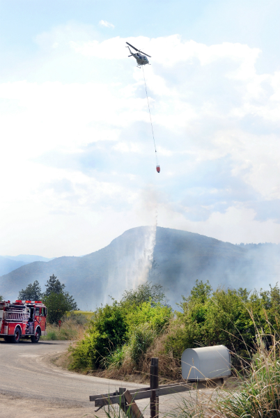
Two helicopters were called in to help control the Abie Lane Fire, which was slowly crawling it’s way up Mt. Hull toward the Swanson Mill Road. The helicopters were dipping water out of the Okanogan River and dropping it on hotspots.
Fire crews and equipment from the state Department of Natural Resources, Mt. Hull, Oroville and Tonasket fire departments were on the scene Sunday. They were putting out flare ups as the fire burned its way up the hill, as well as directing the two helicopters helicopters that were engaged in dumping buckets of water scooped out of the nearby Okanogan River on the hot spots. A dozer line dug was dug around the entire fire, according to Emergency Management.
The B.C. Wildfire Service suspects the Richter Creek Wildfire, which began burning Monday approximately seven miles west of Osoyoos, BC, to be human-caused.
The fire, which can be seen from the U.S. near the Nighthawk/Chopaka border crossing, is being described as “out of control” by BC authorities..
According to our sister newspaper, the Keremeos Review, B.C. Wildfire Service crews are responding to the fire.
Fire information services said they’re calling it the Richter Creek Fire and as of Monday afternoon had stretched out 15 hectares fire wide with smoke from Osoyoos and the B.C. Highway 3, said the Review. As of Tuesday morning the fire had grown to 250 hectares (617 acres).
“The fire is classified as out of control and is expected to spread quickly so it may be a lot more than 10 hectares fairly soon,” said Fire Information Services Hannah Swift on Monday.
She said air support responded earlier, but were called off due to smoke. At the time, Swift said there were two helicopters on route and 28 firefighters on the ground fighting the fire. No structures were in danger at that time.
“The fire is classified as out of control and is expected to spread quickly so it may be a lot more than 10 hectares fairly soon,” said Fire Information Services Hannah Swift on Monday.
An evacuation alert was issued on Monday evening by the Regional District of Okanagan-Similkameen emergency operations centre for one property. It is located in Cawston, approximately 12 km west of Osoyoos.
Meanwhile, Okanogan County Emergency Management said a “smoke check” was being done in the Aeneas Valley area above Tonasket.