Okanogan Complex and Chelan ComplexFire Update
September 3, 2015, 9:00 AM
Fire Information: 877-568-0458 or 877-574-5148, 7 a.m. to 9 p.m.
http://inciweb.nwcg.gov/state/49/#
|
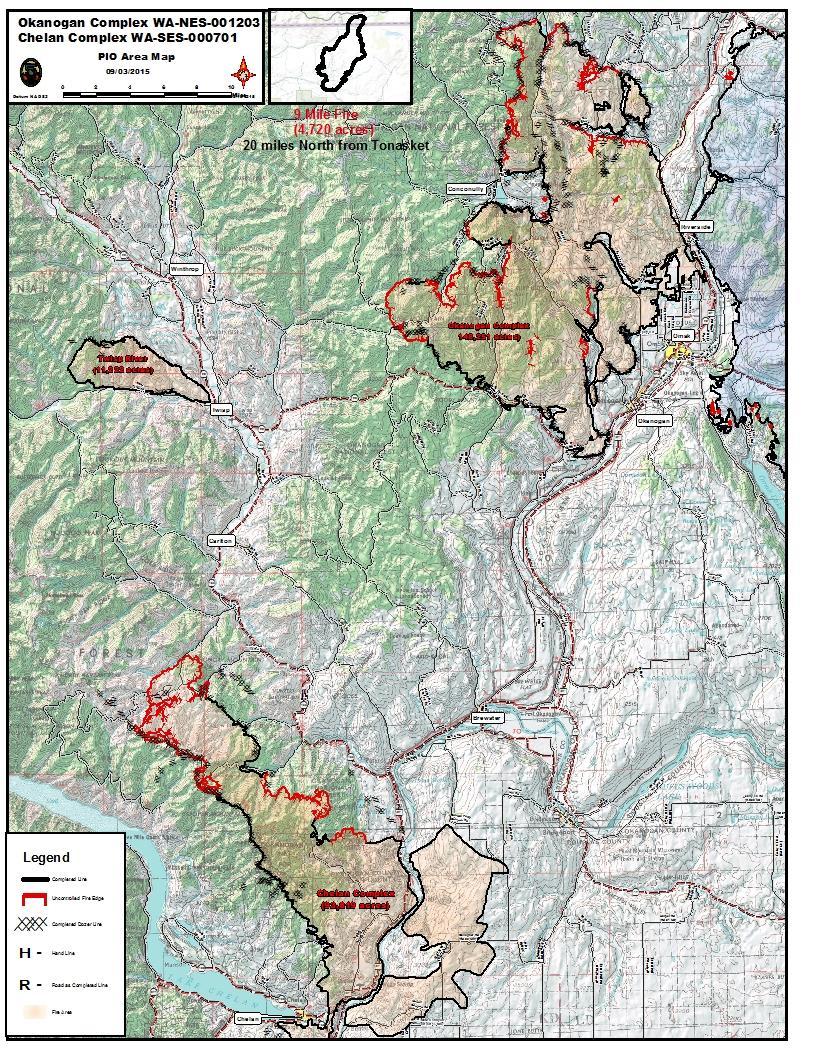
Okanogan Complex |
Chelan Complex |
|
Size: 148,251acres |
Size: 93,819acres |
|
Containment: 50 percent |
Containment: 65percent |
|
Estimated Cost to Date: $29.2million |
Estimated Cost to Date: $13.9million |
|
Injuries: 6 |
Injuries :9 |
|
Residences Burned: 123 |
Residences Burned: 21 |
|
Total Personnel: 1,293 |
Total Personnel: 629 |
|
Committed Resources: 21 crews, 98 engines, 15 dozers, 25 water tenders, 9helicopters |
Committed Resources: 9 crews, 48 engines, 6 dozers, 22 water tenders, 4 helicopters |
CURRENT FIRE SITUATION
With yesterday’s clear skies, wind, and dry air, the fires were more active than they have been in several days. Fire managers got a good perspective on the fires during a reconnaissance flight yesterday and more precisely identified areas that are still holding heat and actively burning.Both the Lime Belt and Chelan fires are most active on their north and northwest ends. Securing the fire lines and holding the fires in place remains the suppression priority. Other priorities are holding the established containment lines, assessing suppression-repair needs, and hauling excess equipment and hose off the fire line so it can be returned to the national fire cache.

OKANOGAN COMPLEX
LimeBelt Fire(132,309 acres, 45 percent contained): On the west side of the fire, southwest of Peacock Mountain, crews were not able to build direct fire line yesterday due to steep, rugged terrain and unsafe conditions. However, the fire remains east of the Loup Loup Canyon Road, and crews might conduct defensive firing operations off the road today in an effort to hold that line and keep the fire east of the road. On the northern tip, the fire was active and produced smoke yesterday. Fire-behavior specialists expect the fire to be active again today as unburned fuels within the established fireline burn in the canyon and on the rim. Firefighters defended structures north of the fire with assistance from dozers and retardant drops, but they will be looking for opportunities to make that area more secure in the coming days.
Twisp River Fire (11,222 acres, 98 percent contained)and Nine Mile Fire (4,720 acres, 98 percent contained):Firefighters on the Twisp River Fire will repair dozer lines, fireline, safety zones, and helispots that were constructed during fire-suppression phase. The Nine Mile Fire remains unstaffed and will be monitoredby air.
CHELAN COMPLEX
Crews secured the fireline around Hungry Mountain yesterday. The fire spotted over the line in a few places on its northwest tip, and yesterday crews worked to contain those spot fires. A hotshot crew assessed the area northwest of Rainy Creek, looking for opportunities to directly suppress the fire. However, the difficult-to-traverse terrain makes the area too dangerous for firefighters. They continue to use aircraft to hold the fire within established lines as they develop a sound strategy for the area.Structure-protection crews continue to defend structures in the following areas: South Fork Gold Creek, Gold Creek, North Fork Gold Creek and McFarland Creek. Where the fire is contained, crews are mopping up, patrolling, and identifying suppression-repair needs.
EVACUATIONSAND ROAD CLOSURES
Information on evacuation and road closures is available from the Okanogan County Emergency Operations Center at 509-422-7348 and on its Facebook page https://www.facebook.com/Okanogan.County.Emergency.Management.
Additional information about closures is available from the Washington State Department of Transportation at www.wsdot.com/traffic/trafficalerts.
http://inciweb.nwcg.gov/state/49/#