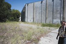

Tonasket city council member Scott Olson (right) envisions a future with a small park, possibly some basketball hoops, murals on the warehouse walls and an improved trail for safe access from town to Chief Tonasket Park, which is beyond the trees at left.
TONASKET – It’s not a plan, or a proposal, or anything solid at this point.
But Tonasket City Councilman Scott Olson hopes that adding walkable, accessible green space to the city is more than just a dream.
Olson looks at the area along Bonaparte Creek – sometimes overgrown and often occupied by transients – and sees a walking path, pocket park, safe transit for kids and an attractive walkabout for visitors.
During a walk through the proposed loop last month – starting and finishing where the creek crosses US-97 between the U.S. Armed Forces Legacy Project and Shannon’s Deli – Olson talked about his vision of connecting the downtown area to the Chief Tonasket Park.
Currently, even getting to the park is tricky for visitors or newcomers. For that matter, it’s easy to miss altogether.
Olson wants that to change for residents and visitors alike.
“The problem right now is there’s no connector (from town to the park),” Olson said. “That’s why we need to do something with that section of Bonaparte Creek. If we can get that RVer to park, pick up a sandwich at Shannon’s or Whistler’s, they may end up taking a stroll after lunch down to the park and river and end up staying in town for dinner.
“Right now they can’t really do that.”
Olson would like to see one or two foot bridges crossing Bonaparte Creek to provide easier access to the Legacy Memorial. A path long the creek would lead to a “pocket park” at the end of Western Avenue, then proceed past the southernmost warehouse to the Chief Tonasket Park parking lot.
“Right now, parents don’t want their kids walking here because of transients,” Olson said of the possible pocket park location, which was empty and clean on this day. “But in talking to the transients, they don’t want to be anywhere near where people are walking. They want to be as far away from making problems as possible. It’s almost a chicken or egg situation.”
Creating a safe crossing over the railroad tracks is one issue that would need to be worked out.
“We don’t think we can go under it,” Olson said. “The sight lines are as good as they are anywhere. That’ll be an issue the lawyers have to work out.”
Beyond the tracks are the old fruit packing warehouses, the southernmost of which faces the creek.
“There’s lots of potential here,” Olson said. “There’s trees, there’s walls (on the warehouse) for murals. I think we could put basketball courts here. And we’re still not far at all from where we parked in town.”
The path opens up into the open space leading into Chief Tonasket Park. Olson said that a safe walkway could be created using row hedges that were thin enough for good sightlines but tall enough to define the walking path.
Currently, anyone walking to the soccer or baseball fields at the park has to come down Fourth Avenue and onto Railroad Avenue, through the row of empty warehouses, sharing the road with traffic.
“To me it’s not a great option for kids right now,” Olson said. “First you have the frantic parent bringing a kid 10 minutes late to a game, and you’ve got kids walking through here. The signage is bad, so they don’t know where to go.
“If you have the kids come down the path, and then the row hedges, you know which way to turn because you’re just following the green path (of hedges). The kids are separated from the traffic. There will be sightlines, but they will obviously not be walking on the road.”
The path itself would divert to the Okanogan River walking path, which winds along the shore though trees for the length of the park.
“The river walk is a hidden gem,” Olson said. “A lot of people just come into the big empty parking lot and never see it, but I just know if you create access and signage for the RVers, they’ll be down here.”
Olson also hopes to find a way to continue the path out the south end of the park – perhaps even open part of it up for vehicle access. Right now there is a two-track road that heads back out to the US-97 access road, but it crosses private property.
“If we can work on getting traffic going out there instead of on Railroad Ave., you’d be able to find the ball fields a lot easier,” Olson said.
“So, you can see if we can make that a walkable circle (back to the Legacy Park), how getting people out and walking, it would change the perception of how beautiful things are really wouldn’t take a lot. The great thing is that it wouldn’t take a whole lot. It’s low infrastructure: doing a land swap here and there, dealing with the railroad, planting some trees and making that path.”
Olson said that he was ready to share his vision with the conservation district and hoping to find grant money to go toward planning the project.
“I know more people have ideas than I do,” he said. “If we can get together and figure out how we can make things better for everybody, that’s my goal. I think something like this we could make a reality within about five years. But we need energy and funding to make it happen.”


